Thanks
Gary


|
Garmin eTrex 30 map help please.Garmin eTrex 30 map help please.Hi, I have just bought the Garmin eTrex 30 and would like to find and install maps of Sarratt in Hertfordshire. Can the eTrex view google earth maps ? if so can anyone help with where and how to install please ?
Thanks Gary Hi G
from what I've read on Etrex 30 you are able to use custom maps, these normally reside on a memory card. There is a limit on the size of map you can use, I believe it is no larger than 100mb or not more than 100 tiles. The custom map is in Google Earth .kml format. IIRC you have to create a folder on your mem card and name it Garmin, within this folder you need to create a sub-folder and name it Custom Maps. your .kml file resides within the Custom Maps folder. Enable it from the Garmin menu. si in dubium effodere
Downloaded the Garmin Basecamp trying to workout how to navigate to UK maps.
Ok a small update , but with some worrys
I bought my Garmin which I was told was brand new, and only taken out of box for pictures. I also bought a 8Gb ScanDisk Ultra microSDHC card with Adapter. First I installed the M/SD into its adapter and inserted into my laptop to see if all was ok Laptop would not recognize I remembered the first thing I should do is to create a folder called GARMIN then within that folder create a new folder called CUSTOM MAPS. So before I did anything I connected my Garmin to laptop [NO MICRO CD INSTALLED ] and my computer found the Garmin , I double clicked , thinking I should see no GARMIN or CUSTOM MAP folders because I had not installed my micro sd. I took a screenshot to show you all. 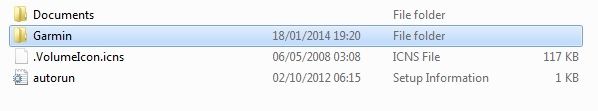 double click on GARMIN FOLDER, 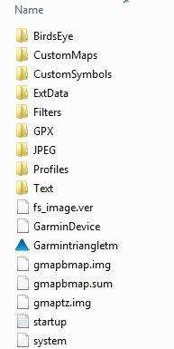 My questions are , is this a new machine ? if not did this person create the GARMIN and CUSTOM MAP folders on the internal drive? OR Whats on the screen shots comes pr-installed from new? I telephoned Garmin UK to see if unit had ever been registered it hadn't. I installed my Micro SD card to see if unit through up any other options or I could see an extra drive but sadly nothing. Any help would be fantastic. Gary.
Hi Gary,
I am by no means an expert but I can tell you the Etrex 30 is a great piece of kit. Look up talky toaster maps on google and you should see a link for talky toaster's site which has a free UK an Ireland map download with instructions. Basically the standard mapping that comes on the unit is poor. I have only used my Etrex 30 for hiking but I was amazed at the talky toaster map definition in comparision to the one that is loaded onto the machine. As to whether your machine is new I dont know. One thing that you need to make sure is that when the Garmin is hooked up via usb you are looking at the contents of the card not the contents of the machine. On the machine itself it should have a custom maps folder also. In my case I downloaded the maps and got them ready on the computer desktop and renamed the files and folders, Inserted the micro sd and copied the files across, then changed the etrex settings to read from the maps on the card instead of the basemap stored on its memory. Its more than capable of doing your job so stick with it. Cheers Stephen Minelab Sovereign GT
SEF 15 X 12 Coil Garrett Pro Pointer Thanks Stephen , where can I find the option so the Garmin Etrex will read from the maps on the card instead of the basemap stored on its memory?
Should I install basemap on the micro sd card as well? Also do you have talky's free UK an Ireland map stalled on your micro sd card? or on basecamp? on your m/cd I HAVE SENT YOU A PM . Stephen. Just a thought, it is compatible with SDHC isn't it?
My older PC will read the older SD cards but not the HC versions so your laptop & the eTrex might be the same. Ady. Garrett Euro Ace
Minelab X-Terra 305 Tesoro Tejon THE ULTIMATE BEACH DETECTING CHALLENGE PROGRESS: £58.60p & 1/2 a 9ct gold ring This gets from bad to worse , I have put micro sd into card reader and plugged into my laptop , it's not allowing me to create 2 new folders. I tried to reformat but get a message saying
This disk is write protected. Any ideas please
Hi Gary,
I have sent you a PM there which should explain some of the stuff you are having problems with. To change where the Etrex 30 looks to for the map go to Setup then Map then Map Information. That should take you into the screen which shows all maps on the device and the ones on the card. At the moment I have the Worldwide OEM basemap disabled and the British Isles with Contours enabled. Cheers Stephen Minelab Sovereign GT
SEF 15 X 12 Coil Garrett Pro Pointer Thank you Stephen , not well at the moment so thank you all for any help.
Hi,
Can anyone help please. Using a Garmin ertex 30 I have basecamp version 4.2.5 already installed on laptop. All I did yesterday was to switch Garmin on then went out for a few hours As you can see by my picture of the Garmin the light BLUE line tracked my movements. 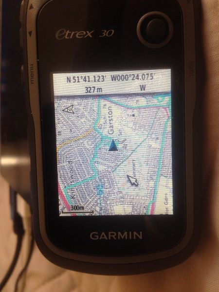 I turn Garmin off then connect using usb cable. I cannot find the option to get the picture from my garmin to Basecamp. The below picture is what I see when garmin is connected using the usb cable. http://i1181.photobucket.com/albums/x43 ... 24f696.jpg The below picture is showing where I have zoomed in , still no BLUE tracking showing. http://i1181.photobucket.com/albums/x43 ... ba4595.jpg I must be doing something daft here.
As said in PM to you.. Guess you remember to save track and give it a name.. Then log on Basecamp and export to, would be no big poblem i hope.. Good luck..
Your Garmin creates the track which is then superimposed on the map. The track is saved on your ET as a .gpx file, this is the file you need to transfer to Basecamp, it will then show you your track on the map in Basecamp. You can also import the .gpx file into Google Earth and see your track displayed there also. The .gpx file will have the date it was created incorporated within its title, so you know which track to import.
si in dubium effodere
Who is onlineUsers browsing this forum: No registered users and 39 guests |

